Images claiming US-Israeli pilots bombed Iranian aircraft decoys are AI-generated
- Published on March 13, 2026 at 16:01
- Updated on March 13, 2026 at 16:06
- 5 min read
- By Tendai DUBE, AFP South Africa
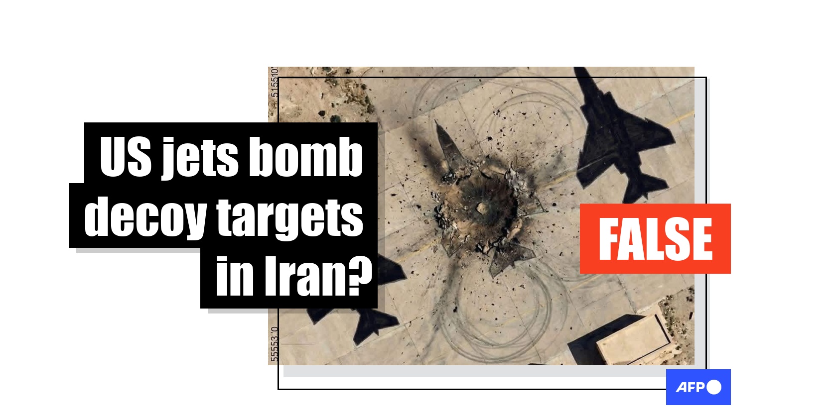
As the war between Iran, the United States and Israel rages on in the Middle East, social media users have circulated satellite images claiming US-Israeli pilots were duped into bombing painted aircraft decoys in Iran. However, this is false; the images were created using artificial intelligence software and do not show real strikes.
“So Israel and USA have being Bombing Paintings not Real Jets IRAN HAD MOVED ITS ACTUAL JETS UNDERGROUND BEFORE THE WAR BEGAN (sic),” reads one such Facebook post published by a South African account on March 6, 2026.
The post includes what appears to be a satellite image of an airfield showing a bomb crater flanked by two painted silhouettes resembling military jets.
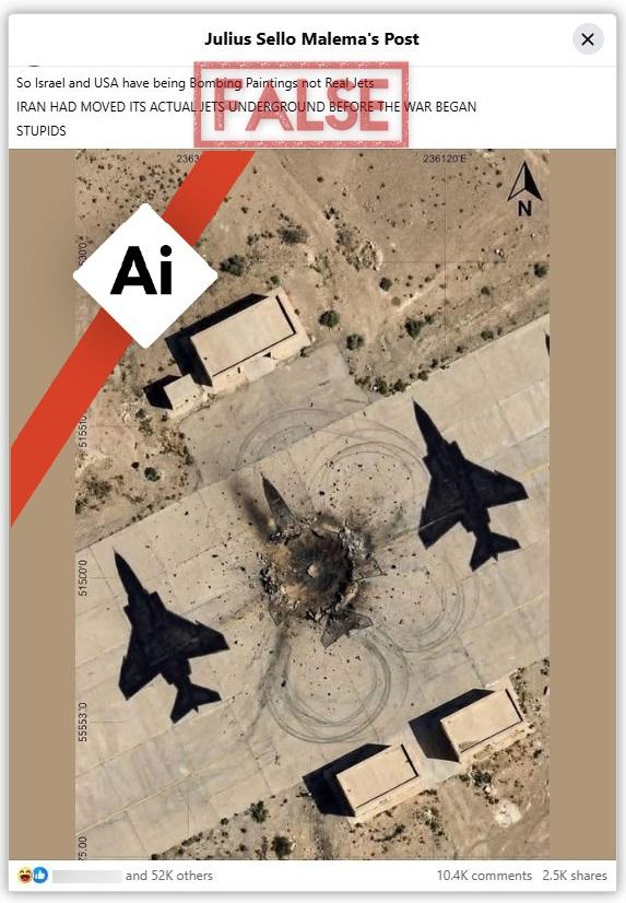
Shared more than 2,500 times, the post was published by a Facebook account posing as South African opposition leader Julius Malema (archived here).
Similar posts were shared in Spanish, Bulgarian, Greek and Romanian.
In a statement read out on Iran’s state television on March 12, 2026, Iran’s new supreme leader, Mojtaba Khamenei, vowed to avenge the deaths caused since the war with the US and Israel began (archived here).
In the remarks, reportedly his first since succeeding his father, Ali Khamenei, he condemned the strikes that killed the former leader on February 28, 2026, triggering a wider Middle East war.
Iran has since targeted US-Israeli interests across the Gulf and disrupted the strategic Strait of Hormuz, a key global oil shipping route. Battlefield accidents, including the downing of three US fighter jets by allied Kuwaiti air defenses, have also occurred (archived here and here).
The middle eastern country has previously used decoys to mislead enemy targeting -- for instance the floating radar-reflecting decoys deployed during the 1980-1988 Iran-Iraq war (archived here).
But claims that satellite images show the US and Israel were tricked into bombing fake targets in Iran in the current war are false.
AI-generated images
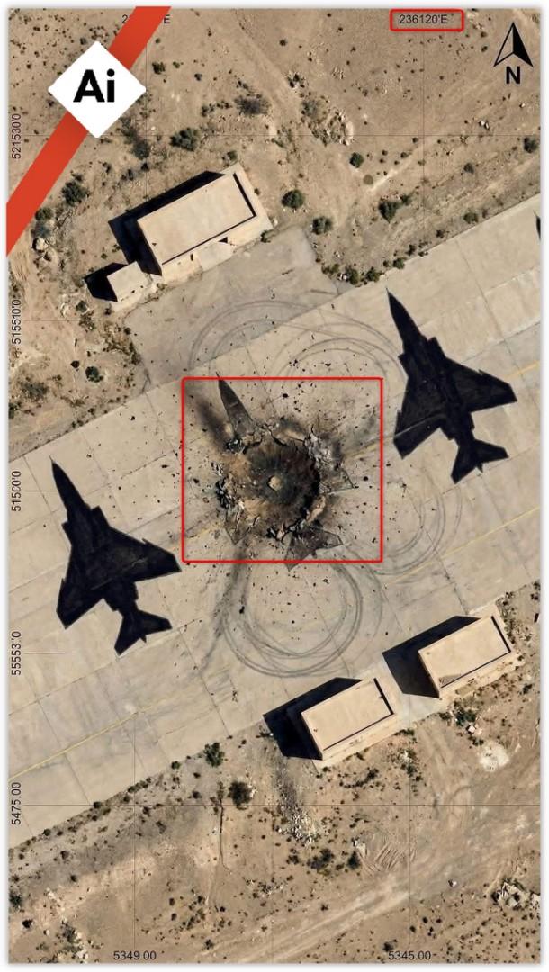
The image shared on Facebook bears the hallmarks of manipulation, including gibberish coordinates along the edges.
For instance, the “E” (east) marker appears where “N” (north) would normally be, while the latitude and longitude markers do not correspond to any recognised global coordinate system or known location.
The jet silhouettes also appear perfectly identical, as if they were duplicated, and are disproportionately large compared to the surrounding buildings.
Additionally, the blast zone is oddly symmetrical, with multiple neat circular patterns around the crater that appear decorative rather than consistent with a real explosion.
The overall image also looks too sharp and clear, with unusually vivid contrast, unlike genuine satellite imagery, which usually exhibits slight blurring or atmospheric distortion.
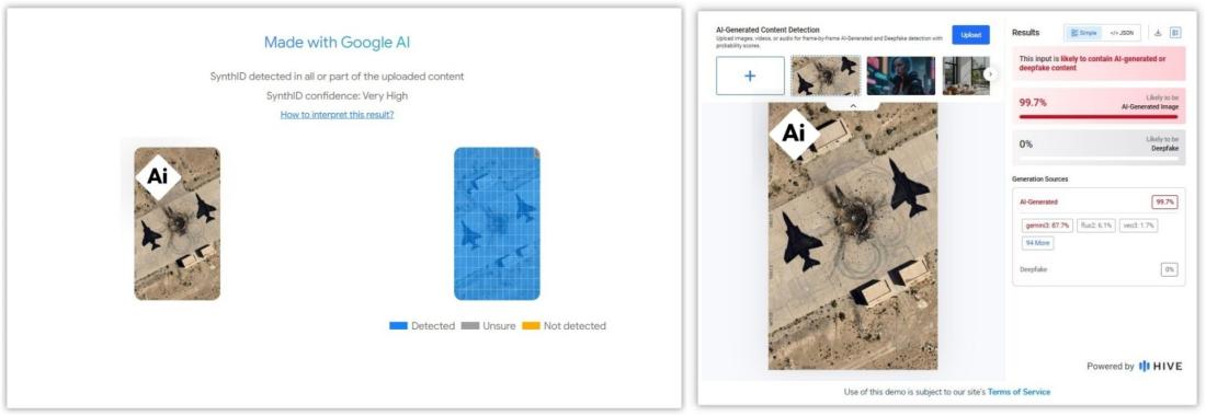
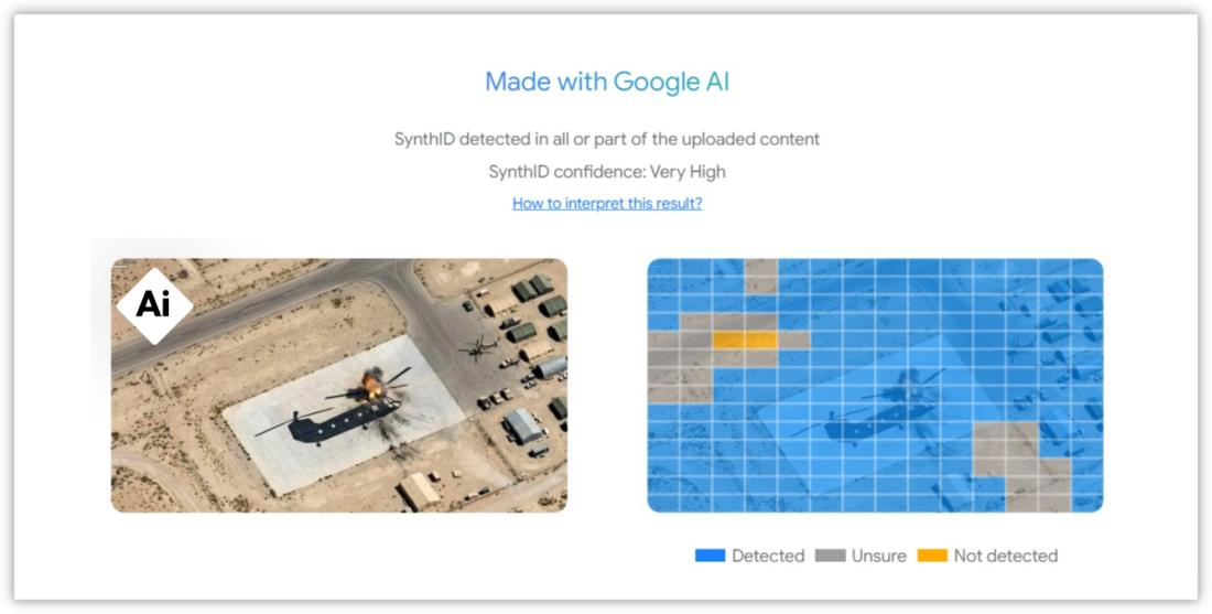
Two different detectors used by AFP Fact Check to analyse the image concluded that it was produced by an AI tool, most likely belonging to Google.
This is according to the tech company’s SynthID technology, which can detect its own invisible watermarks on content created by one of Google’s AI models, like Gemini or Veo.
A second analysis with Hive Moderation found a likelihood of 99 percent that the image was AI-generated.
Other images of alleged decoy aircraft drawings purportedly used by Iran to deceive enemy aircrafts have circulated online with a similar claims, including this Facebook post that was archived before it was deleted.
“If true then, IRAN-10 U.S- nil. Iran pranked the US and Israel by placing painted jets at their bases instead of real aircraft. Iran had moved its actual jets underground before the war began (sic),” reads the post, published by a Kenyan account on March 5, 2026.
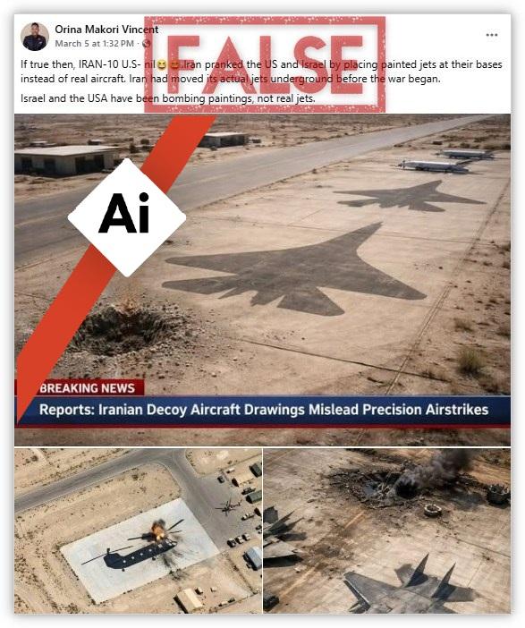
Again, the SynthID detector found the image of the helicopter -- shown from a side view instead of an aerial perspective -- was “made with Google AI”.
A separate analysis by Hive Moderation also concluded that the first two images in the now-deleted post were entirely digitally made.
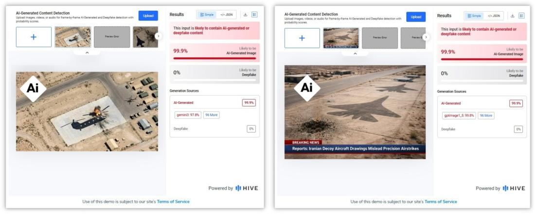
Image Whisperer also detected a high probability that the third image was AI-generated.
The images were shared elsewhere separately with similar claims, including here, here, and here.
Satellite imagery misinformation
The fake satellite images follow the emergence of imposter open-source intelligence (OSINT) accounts on social media that undermine the work of credible digital investigators.
“Due to the fog of war, it can be very difficult to determine the success of an adversary’s strikes,” information warfare analyst Tal Hagin told AFP (archived here).
“OSINT came as a solution, using public satellite imagery to circumvent the censorship. But it’s now being preyed upon by disinformation agents,” he added.
Open-source intelligence researcher Brady Africk told AFP that just like other forms of misinformation, manipulated satellite imagery can have real-world impacts when shared "without verifying its authenticity".
"This can have effects that range from influencing public opinion on a major issue, like whether or not a country should engage in conflict, to impacting financial markets," he said.
On March 10, 2026, American company Planet Labs PBC said it had extended the delay for public access to its Middle East satellite imagery to 14 days to protect countries in the region allied with the US (archived here).
The move follows an earlier decision in March to introduce a 96-hour delay on the release of its high-resolution satellite images, which are normally made publicly available just a few hours after capture.
Read more debunks by AFP Fact Check on the Mideast war here.
Copyright © AFP 2017-2026. Any commercial use of this content requires a subscription. Click here to find out more.
Is there content that you would like AFP to fact-check? Get in touch.
Contact us