Posts falsely claim Hurricane Helene appeared suddenly on radar
- This article is more than one year old.
- Published on September 27, 2024 at 22:36
- 4 min read
- By Manon JACOB, AFP USA
"Weird how 'Hurricane Helene' literally pops up out of nowhere according to The Weather Channel's own radar," says a September 25, 2024 post by Stew Peters, a conservative commentator who has previously spread numerous conspiracy theories on a wide range of topics.
It includes a screen recording of The Weather Channel app's radar imagery of Helene from September 25.
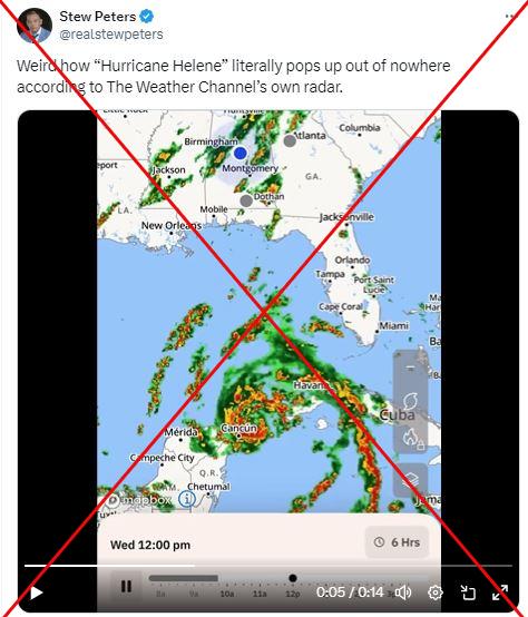
The same claim also circulated on Facebook echoing previous conspiracy theories by climate skeptics about weather manipulation and natural disasters debunked by AFP.
As of September 27, the massive hurricane had knocked out power for millions of people across southeast United States and caused multiple deaths after it slammed into the Florida coast.
But the coastal communities had warning of the storm, with US meteorologists tracking Helene using satellites for days before its landfall in Florida on September 26.
The Weather Company -- which owns the Weather Channel and its app -- said that the network's "meteorologists were tracking Helene's path for days to keep people informed and safe."
This can be easily observed in the coverage available on The Weather Channel's website, including here (archived here).
The spokesperson said that the visual effect of the storm suddenly appearing in the online video is the result of different datasets being used in the app's display.
"While the storm seems to 'pop up' during that radar imagery video loop shown in The Weather Channel app, this illusion can occur when looking at data that uses both actual, observed radar data (which has already occurred) and forecast data (which is a future prediction). Because it's moving from observed data at the beginning of the video loop to forecast data as the loop advances into the future, some jumps or seams can occur," the spokesperson told AFP on September 27.
Limits of radar
Marshall Shepherd, Director of University of Georgia's Atmospheric Sciences Program (archived here), said the posts showed "sheer ignorance."
He told AFP on September 27: "Radar has limited range. A simple solution is to look at the satellite imagery."
Satellite images first showed Helene approaching US coasts in the Gulf of Mexico as a tropical storm, as early as September 24 -- then the storm intensified and developed into a hurricane around September 25 (archived here).
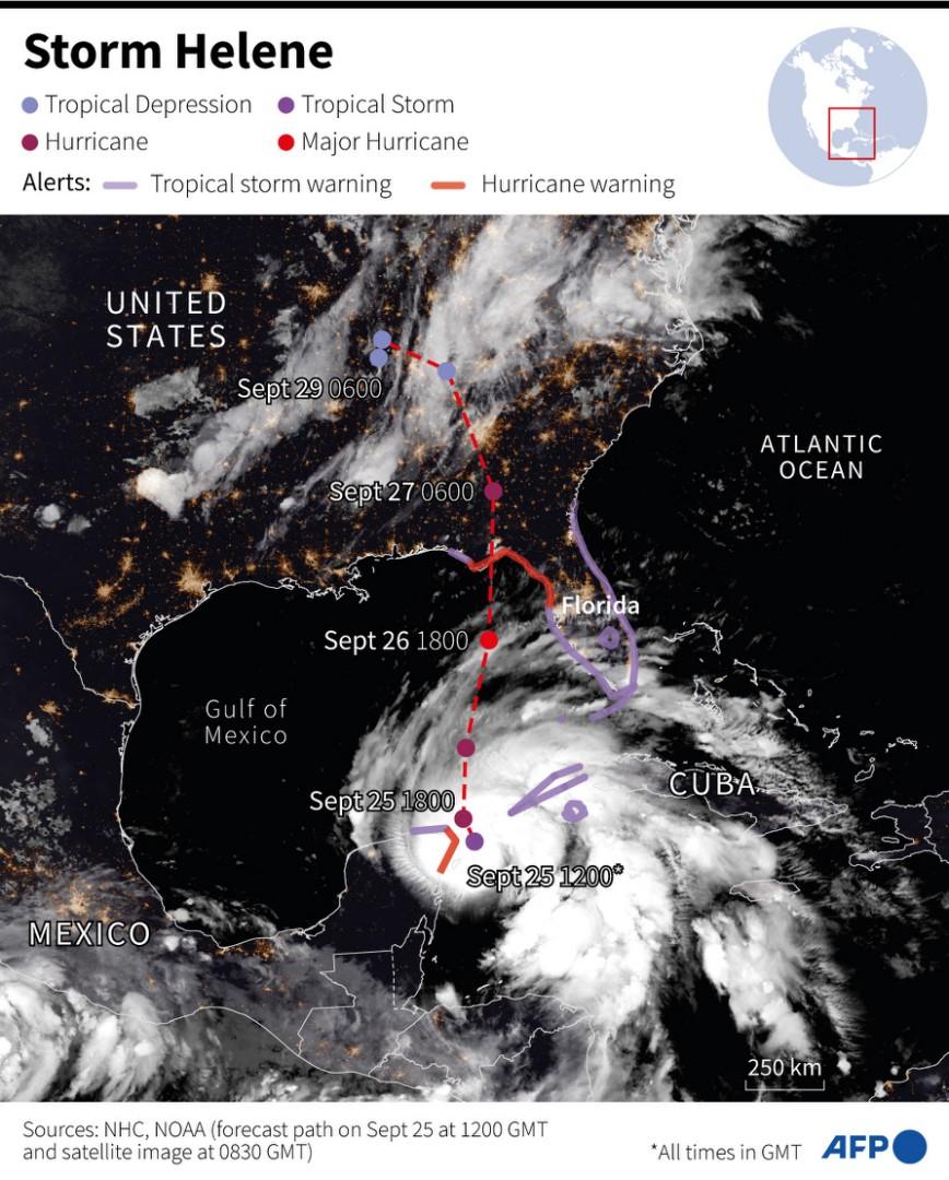
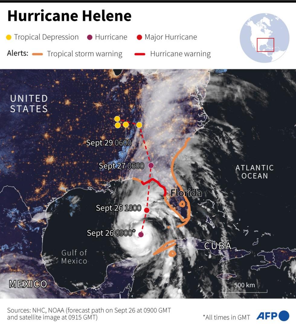
"No, Helene most definitely did not pop out of nowhere. I first wrote about it in a blog post back on September 17, and then again on September 23 and every day since," Brian McNoldy, a senior research associate in atmospheric science at the University of Miami, told AFP on September 27 (archived here, here and here).
"Land-based radars do have a finite range," McNoldy said and country-specific radars may only show part of a storm's course.
"If you just looked at the one from the US, it would seem like the storm just appears out of the nowhere, but that's obviously not the case -- it was simply too far away and then gradually tracked into closer range."
Potential climate ties
While the 2024 Atlantic hurricane season (archived here) has been thus far less busy than predicted, the National Hurricane Center reported Helene's "historic and catastrophic flooding" and warned of flash floods in Georgia's largest city Atlanta, as well as in South Carolina and North Carolina (archived here).
Scientists can link certain extreme weather events directly to human-caused warming, but it remains too early to draw clear conclusions about the current month.
Helene did see a faster-than-expected intensification, which some scientists attributed to unusually warm waters.
"After forming, Helene traveled over exceptionally warm ocean waters in the Gulf of Mexico," said Andra Garner, an assistant professor at Rowan University in New Jersey (archived here).
For hurricanes to form and strengthen, they need warmer waters, and she told AFP on September 27 that Helene traveled over water as warm as 86 degrees Fahrenheit (30 Celsius).
"From a climate perspective, when we warm the planet, a lot of that extra warmth is going into our oceans—and that warmth serves as an ideal fuel source for a storm like Helene."
Find more of AFP's reporting on climate misinformation here.
Copyright © AFP 2017-2026. Any commercial use of this content requires a subscription. Click here to find out more.
Is there content that you would like AFP to fact-check? Get in touch.
Contact us
