Images of Australian peninsula do not refute sea-level rise
- Published on February 17, 2026 at 22:11
- 4 min read
- By Manon JACOB, AFP USA, AFP Australia
Two images claimed to show Australia's Barrenjoey Peninsula almost a century apart are being held up online as evidence that sea levels are not increasing, despite what the available science has demonstrated. But scientists told AFP that single snapshots of landmarks, in contrast to long-term analyses, cannot measure the rise of sea levels. Australia, like other parts of the world, has recorded high-rising seas on its coasts.
"99 YEARS OF SEA LEVEL RISE PALM BEACH SYDNEY," says text beside two images labeled "1917" and "2016" of a sandy location, shared to Facebook on February 10, 2026.
"For years they called it Global Warming. But they were proven over and over that no such thing is happening."
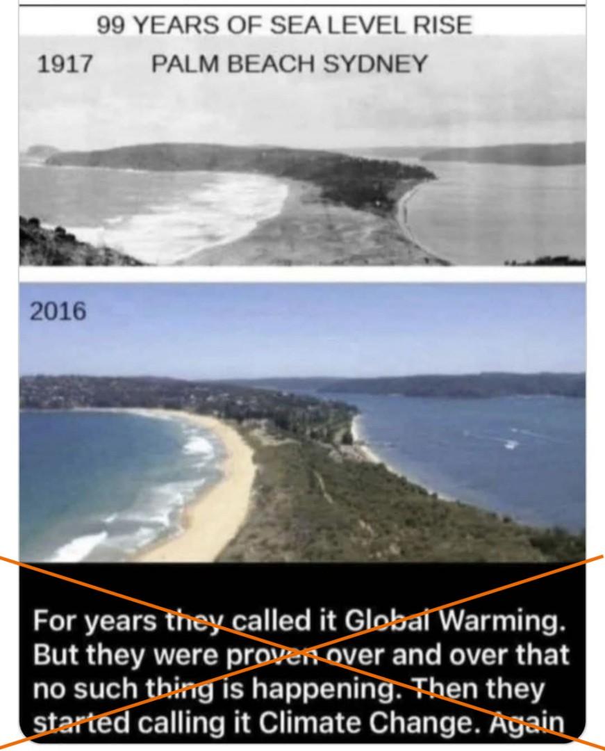
The side-by-side visuals -- one in black and white, dated 1917, and the other in color dated to 2016 -- have circulated across platforms for years.
Google Earth satellite imagery and reverse image searches surfaced nearly identical shots -- confirming that the location is Palm Beach, part of Australia's Barrenjoey Peninsula, and that the photos appear to come from the 1900s and the 2010s, respectively.
But while the images depict the same real location at different times, they do not disprove the science behind sea-level rise and its ties to a warmer climate.
Multiple studies have observed changes in Australia's sea levels over time (archived here and here).
Australia's Department of Climate Change, Energy, the Environment and Water says the rates of sea-level rise since 1993 have been above the global average "over much of the western Pacific, including most of the Australian coastline, and below the global average in the eastern Pacific" (archived here).
Australia's rising seas
An Australian Bureau of Meteorology (BOM) spokesperson told AFP that "there isn't a tide gauge at Palm Beach."
"But Fort Denison observations are representative of water levels there," the spokesperson said February 13.
The data at Fort Denison shows an increase in annual mean sea level from 1914 to 2025. Since 1966, the sea level there has risen 2.17 millimeters, or 0.09 inches per year (archived here).
AFP has previously debunked similar misinformation centered on historical images of the fort.
"Just like other weather and ocean variables, some years have higher than average sea levels while other years have lower than average sea levels," the BOM spokesperson said, noting that more accurate conclusions are drawn from "long-term patterns using linear trends or other methods that consider all years of data, rather than simply computing the difference between the first and most recent observation".
Jayantha Obeysekera, director of the Sea Level Solutions Center at Florida International University, added February 12 that the side-by-side comparisons being made online "are not useful unless they specify the time of the year and also the time of the day when they were taken" (archived here).
Shoreline stability
Coastline expert Andrew Short told AFP on February 12 that Palm Beach's shorelines are relatively stable with regard to erosion, which explains why the two images from different time periods appear to show similar amounts of land (archived here and here).
The side-by-side does not "necessarily indicate erosion" but instead "just that the dune was bare of sand" until its revegetation in the mid-1980s, said Short, who has investigated Australia's 12,000 beaches.
According to Digital Earth Australia, the country's geoscience data and digital program, 78 percent of Australia's shores are stable, 11 percent receding and 11 percent prograding.
"Widespread retreat is not happening, yet," Short said.
With climate warming and sea-level rise, some areas might see beaches erode, while others might actually gain sand. The exact effect will vary between coastal regions (archived here and here).
Man-made infrastructures -- including systems sought to manage erosion -- as well as urban expansion risk worsening erosion, and coastal inundation is likely to impact larger areas with the rise of sea levels (archived here).
Current and future threats
The rise of sea levels is a persistent threat to humans and global ecosystems.
NASA states that human activities have contributed to about 70 percent of the increase observed since 1970, with the percentage approaching 100 percent as time goes on (archived here).
Research from the Intergovernmental Panel on Climate Change (IPCC) shows a continued acceleration of sea-level rise (archived here).
The impact of rising seas is also not homogeneous worldwide.
Certain locations, such as the Pacific Island regions, face greater risks and are projected to experience irreversible changes in the next 30 years, according to NASA (archived here).
An increase in the ocean watermark of nine inches (23 centimeters) over the last 125 years has imperiled many small island states and amplified the destructive power of storm surges worldwide.
"Coastal ecosystems can migrate landward or grow vertically in response to SLR (sea-level rise), but their resilience and capacity to keep up with SLR will be compromised by ocean warming and other drivers, depending on regions and species," the IPCC noted in a 2022 report (archived here).
AFP has previously debunked other posts misrepresenting historical landmark photos to deny climate change and its impacts.
Copyright © AFP 2017-2026. Any commercial use of this content requires a subscription. Click here to find out more.
Is there content that you would like AFP to fact-check? Get in touch.
Contact us