AI-generated image misrepresented as hurricane damage on coastal town in Jamaica
- Published on November 6, 2025 at 10:38
- 3 min read
- By Nyan Tun SHEIN, AFP Thailand
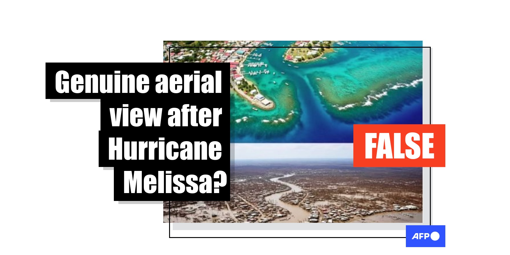
Pictures of Hurricane Melissa's damage -- including buildings reduced to rubble, debris-strewn streets, and entire neighbourhoods submerged in floodwaters -- circulated online after it made landfall in Jamaica in October. However, one image shared in social media posts claiming to show Jamaica's coastline after the Category 5 hurricane hit was in fact AI-generated.
"The coast of Jamaica before Hurricane Melissa made landfall and the image after yesterday," reads a Burmese-language Facebook post uploaded on October 30, 2025.
The post -- which has been shared more than 1,700 times -- features an aerial comparison of a coastal area, with the top image showing homes surrounded by a blue ocean, while the bottom image depicts muddy waters and destroyed houses.

Hurricane Melissa became the most intense storm to make landfall in Jamaica in 90 years when it barreled into the Caribbean nation on October 28 as a Category 5 hurricane packing winds of 300 kilometres (185 miles) per hour (archived link).
AFP distributed photos showing flooded roads and collapsed buildings after the storm passed.
At least 32 people were killed in the country -- a relatively low death toll thanks to disaster planning, including mass evacuations and prepositioned aid in the country, according to the Red Cross (archived link).
Similar claims using the same image were also shared in English, Greek, Portuguese, Spanish and Thai.
"I can sympathise," one user commented, while another said: "Stay safe from natural disasters."

But a reverse image search found that Google has flagged the visual as "Made with Google AI."
A spokesperson for the tech giant has previously said that when a SynthID watermark is detected, it confirms "the image has been generated or modified with AI" (archived link).

Further keyword search on Google found the image was uploaded to a Facebook account belonging to "Joemar Sombero" on October 30 (archived link).
Its caption reads in part, "Black River, Jamaica -- wiped out by Hurricane Melissa", but then goes on to say it contains visuals made with AI.
The account has repeatedly posted other images related to natural disasters, along with labels that they were fabricated.

A subsequent search on Google Maps satellite view of Black River, Jamaica, reveals a topography that differs from the circulating image (archived link).
Unlike the AI-generated image, the satellite picture shows there is little to no development on the right-hand side of the coastal town, while the left side appears more built up.
The river separating the two sides also appears straighter and narrower than the winding waterway in the fabricated image.
Despite the rapid progress of generative AI, errors still appear in AI-generated content. These flaws are often the clearest signs of a fabricated image.

AFP debunked other misinformation related to Hurricane Melissa here.
Copyright © AFP 2017-2026. Any commercial use of this content requires a subscription. Click here to find out more.
Is there content that you would like AFP to fact-check? Get in touch.
Contact us