
Tube-shaped clouds spotted over eastern Australia are a natural phenomenon, not 'chemtrails'
- This article is more than two years old.
- Published on June 13, 2024 at 07:04
- 2 min read
- By AFP Australia
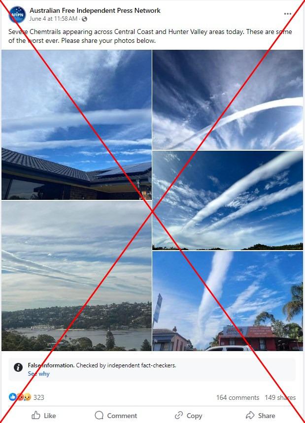
The photos were shared more than 100 times after being posted on Facebook on June 4, 2024.
"Severe Chemtrails appearing across Central Coast and Hunter Valley areas today," read part of the photos' caption, which referred to regions in the eastern Australian state of New South Wales (NSW).
"These are some of the worst ever."
The "chemtrails" conspiracy theory alleges that white streaks in the sky left from aircraft are toxic chemicals or biological weapons used as part of secret government programmes (archived link).
The images were repeatedly shared on Facebook by users who also claimed they showed "chemtrails".
One person called it "insane chemtrailing", while another claimed the "chemicals" would affect "water, soil and food".
"Shoot em out of the sky," suggested one user.
The images were posted on the same day that similar photos flooded social media.
Australian news outlet news.com.au included similar images in an article that said the "rare cylindrical cloud formation" had wowed and baffled NSW residents (archived link).
But experts say there is no evidence to support the "chemtrails" conspiracy (archived link). AFP has also previously debunked claims about chemtrails here and here.
'Not chemtrails'
"These are not chemtrails, they are roll clouds," Professor Jason Middleton, an aviation meteorology expert at the University of New South Wales told AFP on June 11, 2024.
Middleton reviewed the photos shared in the false post and confirmed they showed a type of volutus cloud formed at a lower altitude under a rare set of circumstances.
He added that westerly winds on June 4 was "conducive to generating the roll clouds to the east."
Australia's Bureau of Meteorology also posted about the rare weather phenomenon on its verified Facebook page on June 4 (archived link).
The bureau said the clouds appeared to have developed "due to a combination of an upper level temperature inversion and wind speed shear".
It explained that a temperature inversion occurs when atmospheric conditions cause the air to get warmer higher up in the atmosphere.
Under these conditions, air that rises and forms clouds will find itself cooler than the air around it and start to sink, which leads to flat clouds. These are given a "rolling appearance" by changes in wind speed or direction over short distances that push the top of the cloud faster than the bottom.
Copyright © AFP 2017-2026. Any commercial use of this content requires a subscription. Click here to find out more.
Is there content that you would like AFP to fact-check? Get in touch.
Contact us