
Old footage of flooding in northern Philippines falsely shared as impact of Typhoon Gaemi
- This article is more than two years old.
- Published on July 30, 2024 at 03:32
- 2 min read
- By Lucille SODIPE, AFP Philippines
The video of people trying to clear a bridge submerged by floodwaters was shared on Facebook on July 24, as the Philippine capital Manila and neighbouring areas were battered by monsoon rains intensified by Typhoon Gaemi.
"Sirs, please take care because you have families waiting for you," reads Tagalog-language text overlaid on the video.
Its caption -- using the Philippine name for Gaemi -- added, "That's the bridge at Luvers, the river is overflowing. Storm, please stop #supertyphoon #carina".

The storm shut government offices, suspended classes forced the cancellation of more than 70 domestic and international flights, and cut power to tens of thousands of people.
Police said 30 people were killed.
But the video -- which was also shared elsewhere on Facebook here and here -- was not filmed during the storm.
Old typhoon clip
Keyword searches on Google show the video was posted on YouTube on October 29, 2022, at the height of Tropical Storm Nalgae (archived link).
"Overflowing (river) on a bridge in Luvers, Eastwood, Rodriguez, Rizal," the caption read. Its description also included "#paengph" -- Paeng was the Philippine name for Nalgae.
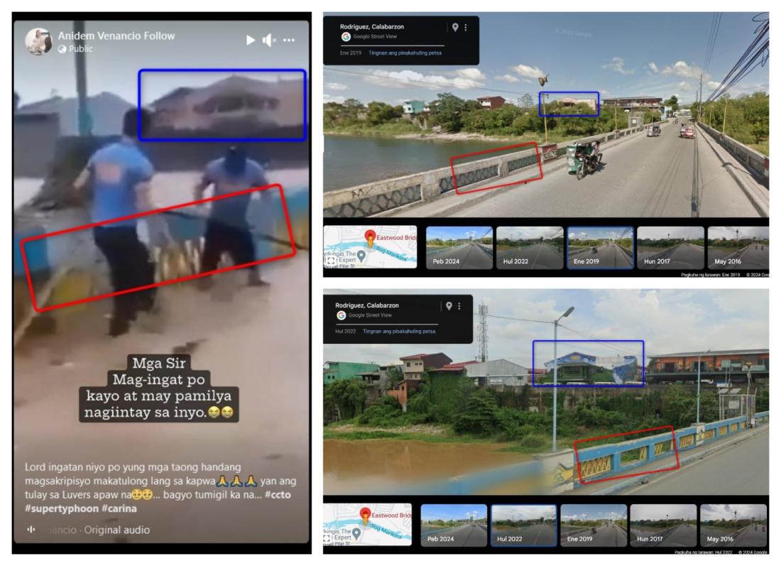
Visual clues in the clip checked against Google Street View imagery of the location, however, suggest the video was in fact filmed between January 2019 and July 2022.
A building visible in the background of the video is a different colour to how it appears on Google Street View imagery from July 2022, and more closely resembles how it appears in January 2019 (archived links here and here).
The colour of the bridge's guardrails are the correct colour -- blue and yellow -- in Google Street View imagery from July 2022, but were unpainted in the imagery from January 2019.
Below is a screenshot comparison between the falsely shared video (left) and Google Street View imagery from January 2019 (upper right) and July 2022 (lower right):
Keyword searches on Google about flooding in the town of Rodriguez, Rizal province, during this time period led to reports from local news outlets Philstar, Inquirer and GMA News about Typhoon Vamco -- known locally as Ulysses -- that barrelled across the country in November 2020 (archived links here, here and here).
According to an article published by the Philippine's environment department, in parts of Rodriguez "the flood was so deep that only roofs of one-story houses were visible" (archived link).
Further keyword searches on Facebook and YouTube led to similar images of water swamping the bridge during and after Vamco here, here, here and here (archived links here, here, here and here).
A representative from San Isidro village emergency command centre -- where the bridge is located -- told AFP on July 24 that the video is "fake news".
An announcement posted on their Facebook page on July 24 said the bridge remained passable, and the footage circulating online was in fact recorded during Vamco (archived link).
Copyright © AFP 2017-2026. Any commercial use of this content requires a subscription. Click here to find out more.
Is there content that you would like AFP to fact-check? Get in touch.
Contact us