Sudan crisis posts misrepresent old Google Earth image
- Published on December 3, 2025 at 08:15
- Updated on December 4, 2025 at 10:12
- 3 min read
- By Raevathi SUPRAMANIAM, AFP Malaysia
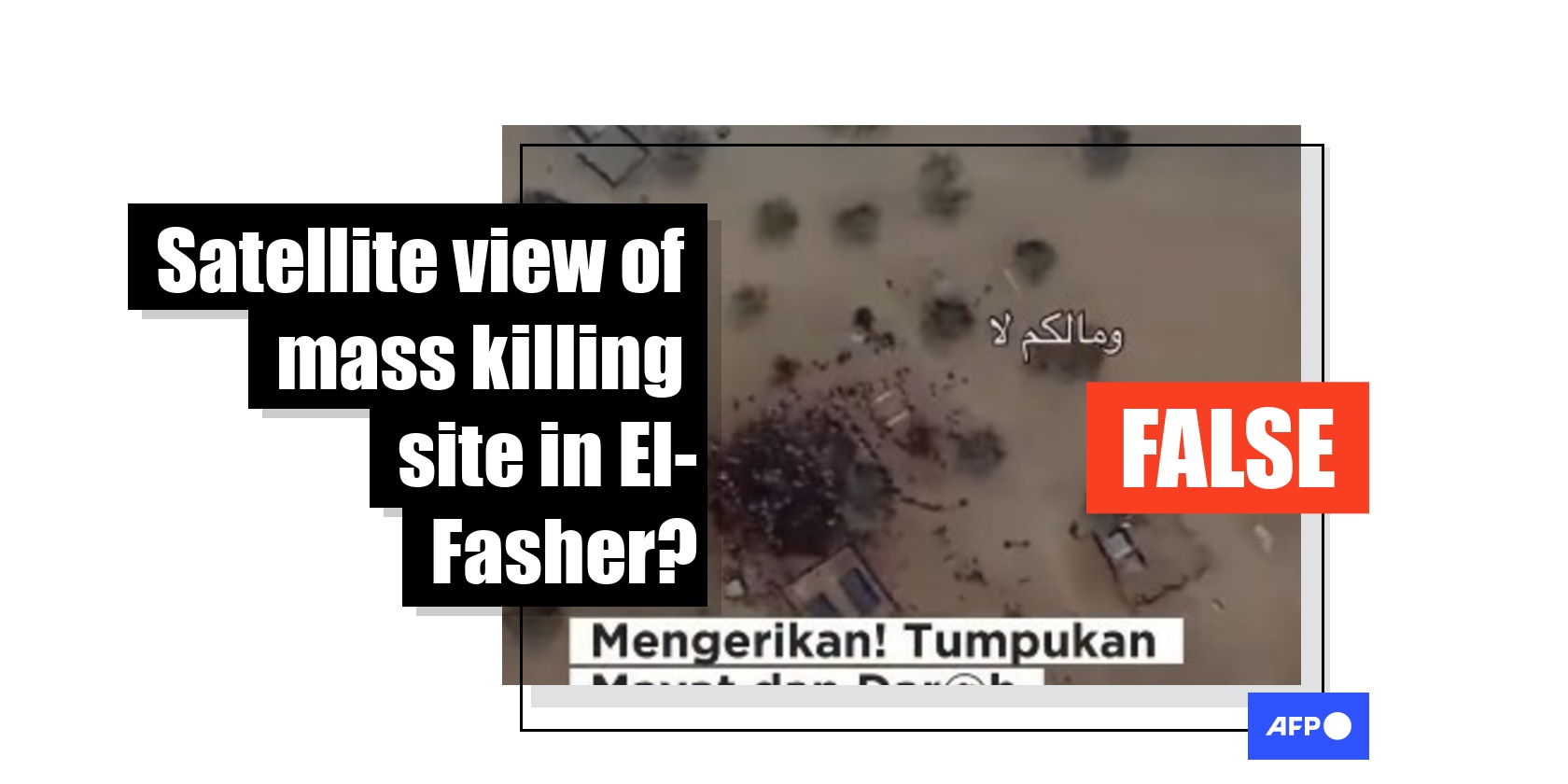
Reports of executions allegedly committed by Sudan's paramilitary Rapid Support Forces following their capture of El-Fasher have sparked international outrage. But a widely shared Google Earth image does not show piles of bodies in the city, contrary to false online posts. The visual is old and was taken in a town nearly 400 kilometres (250 miles) away, while an expert told AFP it depicts livestock, not human remains.
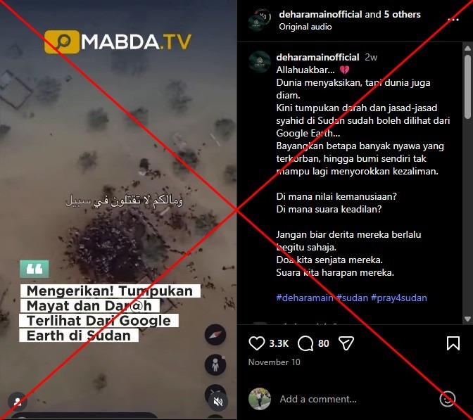
"Now the piles of bodies and blood of the martyrs in Sudan can be seen from Google Earth," reads part of a Malay-language Instagram post shared November 10, 2025. The sticker text in the video repeats the claim.
The clip is a screen recording of a Google Earth satellite image that zooms in on an area of dark ground, where several shapes appear to resemble bodies.
The same visuals were shared alongside similar claims on Facebook and Threads, and circulated in South Africa, the Philippines, Iraq, Vietnam, Indonesia and Bangladesh.
The comments were filled with crying emojis and prayers, suggesting many users believed the posts.
The paramilitary RSF has been accused of committing mass killings and other atrocities since it captured El-Fasher -- the army's last remaining stronghold in western Darfur -- on October 26, 2025 (archived link).
The group has been at war with the Sudanese army since April 2023.
A report by Yale University's Humanitarian Research Lab said satellite images gave them reason to believe much of the population in El-Fasher may be "dead, captured, or in hiding" (archived link).
The lab identified at least 31 clusters of objects consistent with human bodies across neighbourhoods, university grounds and military sites.
But the satellite image circulating online -- which is not from the Yale report -- is unrelated to the alleged atrocities in El-Fasher.
'Probably a camel line'
A reverse image search led to an Instagram post from November 14, 2025, which shared the same image seen in the video and the same false claim.
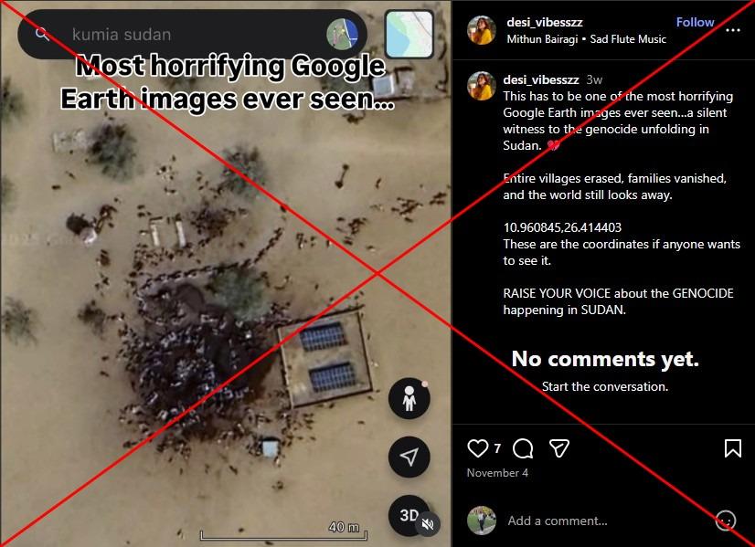
But the Google Earth search bar is visible and displays the location as "Kumia, Sudan", a town some 400 kilometres (250 miles) away from El-Fasher, while the caption included the coordinates for the area.
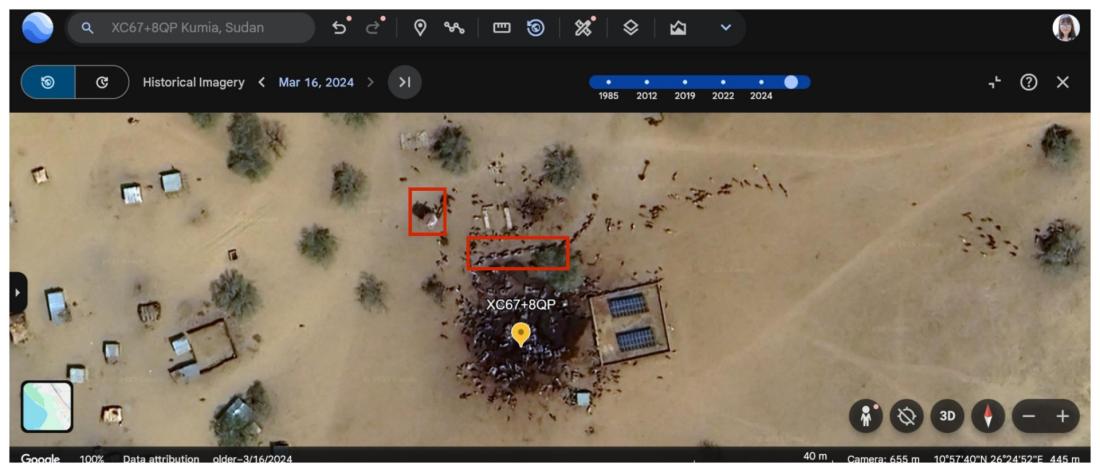
A search on Google Earth returned the same imagery seen in the false posts. Historical data shows the satellite image was captured on March 16, 2024. The same scene also appears in imagery from February 2024 and March 2022.
Open source investigator Benjamin Strick told AFP that his analysis of the area surrounding the location being shared in the posts found many similar looking places -- indicating they are most likely animal gathering sites (archived link).
Strick noted that the angle of the shadows -- which can be determined by looking at a tall structure such as the water tower in the image -- visible in the image are too tall to be cast by a human body lying flat on the ground.
"A body has to be pretty big in order to leave a shadow if it's laying flat on the ground. (So it's) probably a camel line, because camels like to stand in lines, especially when they're in convoys," he told AFP.
He said the dark patch on the ground, which some social media users claimed was blood, is more likely a mixture of manure and water. The same dark area appears in satellite images dating back to 2022.
An AFP journalist in Sudan confirmed Kumia is a local hub for trade and sees frequent camel movement, adding the image "could be a local slaughterhouse".
AFP Fact Check has debunked several claims related to the Sudan crisis here.
December 4, 2025 Updated to add details from AFP journalist in Sudan
Copyright © AFP 2017-2026. Any commercial use of this content requires a subscription. Click here to find out more.
Is there content that you would like AFP to fact-check? Get in touch.
Contact us